

ņä£ ļĪĀ
ĒĢ┤ņāüĻĄÉĒåĄ ļČäņäØņØĆ ņäĀļ░Ģ ļ░Å ĒĢŁļ¦īņØś ņĢłņĀäņØä ņ£äĒĢ┤ ļīĆņāü ĒĢ┤ņŚŁņØś ĒÖśĻ▓ĮņĀüņØĖ ĒŖ╣ņä▒ņØä ĒīīņĢģĒĢśĻ│Ā, ņÜ┤ĒĢŁĒĢśļŖö ņäĀļ░ĢņØś ĻĄÉĒåĄ Ēī©Ēä┤ņØä ļČä ņäØĒĢśļŖö ņØ╝ļĀ©ņØś Ļ│╝ņĀĢņØä ļ¦ÉĒĢ£ļŗż. ņØ┤ļŖö ņĄ£ĻĘ╝ ĒĢ┤ņāü ĻĄÉĒåĄļ¤ēņØ┤ ļŖśņ¢┤ ļéśĻ│Ā, Ļ┤ĆņĀ£ ņśüņŚŁņØ┤ ĒÖĢņןļÉ©ņŚÉ ļö░ļØ╝ ĻĘĖ ĒĢäņÜöņä▒ņØ┤ ņ”ØĻ░ĆĒĢśĻ│Ā ņ׳ņ£╝ ļ®░, ļČäņäØļÉ£ Ļ▓░Ļ│╝ļŖö ĒĢ┤ņ¢æņé¼Ļ│ĀņØś ļ░£ņāØ ņ£äĒŚśņØä ņżäņØ┤Ļ│Ā, ĒĢŁļ¦īņØś ĒÜ© ņ£©ņä▒ņØä ĻĘ╣ļīĆĒÖöĒĢśļŖöļŹ░ ņĀüĻĘ╣ ĒÖ£ņÜ®ļÉśĻ│Ā ņ׳ļŗż. ĒŖ╣Ē׳, ĒĢ┤ņāüĻĄÉĒåĄĻ┤ĆņĀ£ ņä╝Ēä░(VTS, Vessel Traffic Service)ņŚÉņä£ļŖö ĒĢ┤ņāüĻĄÉĒåĄņŚÉ ļīĆĒĢ£ ļ│┤ļŗż ļŗżĻ░üņĀüņØĖ ļČäņäØņØ┤ ĒĢäņÜöĒĢśļ®░, ņŗżņĀ£ļĪ£ ļČäņäØ Ļ▓░Ļ│╝ļź╝ ļ░öĒāĢņ£╝ ļĪ£ Ļ│äņĀłļ│ä ĒĢ┤ņāüĻĄÉĒåĄ ņĢłņĀäļīĆņ▒ģņØä ņłśļ”ĮĒĢśĻ▒░ļéś ņäĀļ░Ģ ĻĄÉĒåĄļ¤ēņØś ņ”Ø Ļ░ĆņŚÉ ļīĆļ╣äĒĢśņŚ¼ ņ¢┤ņäĀ ļ░Å ņŚ░ņĢł ĒĢŁĒĢ┤ ņäĀļ░Ģ ļō▒ņŚÉ ļīĆĒĢ£ ņ¦æņżæĻ┤ĆņĀ£ļź╝ ņŗżņŗ£ĒĢśĻĖ░ļÅä ĒĢ£ļŗż. ļśÉĒĢ£, ĒĢ┤ņāüĻĄÉĒåĄĻ┤ĆņĀ£ļź╝ ņ£äĒĢ£ Ļ┤ĆņĀ£ĻĄ¼ņŚŁ ļ░Å Ļ┤Ć ņĀ£ņä╣Ēä░ļź╝ ņäżņĀĢĒĢśĻ▒░ļéś Ļ┤ĆņĀ£ņé¼ļź╝ ļ░░ņĀĢĒĢśļŖö ļō▒ Ļ┤ĆņĀ£ ņ×ÉņøÉņØä ĒÜ©ņ£© ņĀüņ£╝ļĪ£ ĒĢĀļŗ╣ĒĢśĻĖ░ ņ£äĒĢ┤ ĒĢ┤ņāüĻĄÉĒåĄ ļČäņäØņØä ņłśĒ¢ēĒĢśĻĖ░ļÅä ĒĢśļ®░, ĒĢŁ ļĪ£Ēæ£ņ¦ĆņØś ņĄ£ņĀü ļ░░ņ╣ś ļ░Å ņĢłņĀä ĒĢŁļĪ£ņØś ņäżĻ│ä, ņĢłņĀäņä▒ ĒÅēĻ░Ć ļō▒ņŚÉļÅä ĒĢ┤ņāüĻĄÉĒåĄ ļČäņäØ Ļ▓░Ļ│╝ļź╝ ĒÖ£ņÜ®ĒĢśĻ│Ā ņ׳ļŗż. ņØ┤ļ¤¼ĒĢ£ ĒĢ┤ņāüĻĄÉĒåĄ ļČäņäØ ņŚÉļŖö ĻĄÉĒåĄ ļ░Ćņ¦æļÅä ļČäņäØ, ĻĄÉĒåĄļźś ļ░Å ĻĄÉĒåĄ Ēś╝ņ×ĪļÅä ņśłņĖĪ, ņČ®ļÅī ņ£ä ĒŚśļÅä ĒÅēĻ░Ć ļō▒ ļŗżņ¢æĒĢ£ ļ░®ļ▓ĢļōżņØ┤ ņĀüņÜ®ļÉśļ®░, ļČäņäØņØś ļ¬®ņĀüņŚÉ ļö░ļØ╝ ņĀüĒĢ®ĒĢ£ ļ░®ļ▓ĢņØä ņäĀņĀĢĒĢśņŚ¼ ļČäņäØņØä ņłśĒ¢ēĒĢśĻ▓ī ļÉ£ļŗż. ĒĢ£ĒÄĖ, Ļ│ĄĻ░äņĀĢ ļ│┤ ļČäņĢ╝ņŚÉņä£ļŖö Ļ│ĄĻ░ä ņĀĢļ│┤ņØś ļ│ĆļÅÖ ņČöņØ┤ļź╝ Ļ▒░ņŗ£ņĀüņ£╝ļĪ£ Ļ┤Ćņ░░ĒĢśĻĖ░ ņ£äĒĢ┤ ņżæņŗ¼ņĀÉ(centroid) ļČäņäØļ▓ĢņØä ņŻ╝ļĪ£ ņé¼ņÜ®ĒĢśļ®░, ņØ┤ļŖö Ļ│ĄĻ░ä ļŹ░ ņØ┤Ēä░ņØś ļ░Ćņ¦æ ļČäĒż ĒŖ╣ņä▒Ļ│╝ ņŗ£Ļ░äņŚÉ ļö░ļźĖ ļ│ĆĒÖöļź╝ ĒīīņĢģĒĢśĻĖ░ ņÜ®ņØ┤ ĒĢ£ ņןņĀÉņØä Ļ░Ćņ¦ĆĻ│Ā ņ׳ļŗż. ļ│Ė ļģ╝ļ¼ĖņŚÉņä£ļŖö ņØ┤ļ¤¼ĒĢ£ ņżæņŗ¼ņĀÉ ĻĖ░ļ▓ĢņØä ņØ┤ņÜ®ĒĢśņŚ¼ ņäĀļ░ĢņØś ĒåĄĒĢŁĒī©Ēä┤ņØä ļČäņäØĒĢśļŖö ļ░®ļ▓ĢņØä ņĀ£ņĢłĒĢśļ®░, ļ¬®Ēż ĒĢŁņØś ņĀüņÜ® ņé¼ļĪĆļź╝ ĒåĄĒĢ┤ ĒĢ┤ņāüĻĄÉĒåĄ ļČäņäØ ļ░®ļ▓Ģņ£╝ļĪ£ņä£ņØś ĒÖ£ņÜ® Ļ░Ć ļŖźņä▒ņØä Ļ▓ĆĒåĀĒĢśĻ│Āņ×É ĒĢ£ļŗż.
ĒĢ┤ņāüĻĄÉĒåĄ ņĢłņĀäņä▒ ĒÅēĻ░Ć ĻĖ░ļ▓Ģ
ĒĢ┤ņāüĻĄÉĒåĄ ņĪ░ņé¼ņŚÉļŖö ļŗżņ¢æĒĢ£ ļČäņäØ ļ░®ļ▓ĢņØ┤ ņĀüņÜ®ļÉśļ®░, ĒŖ╣Ē׳ ĒĢ┤ ņāüĻĄÉĒåĄ ņĢłņĀäņä▒ ĒÅēĻ░Ć ļČäņĢ╝ņŚÉņä£ ĒÖ£ļ░£ĒĢ£ ņŚ░ĻĄ¼ Ļ░£ļ░£ņØ┤ ņ¦äĒ¢ēļÉśĻ│Ā ņ׳ļŗż. ĒĢ┤ņāüĻĄÉĒåĄ ņĢłņĀäņä▒ ĒÅēĻ░ĆļŖö ĒĢ┤ņāüņØś ĒåĄĒĢŁļĪ£ņŚÉ ņäżņ╣śļÉśļŖö Ļ░ü ņóģ ĒĢŁļ¦ī ņŗ£ņäżļ¼╝ņØś ņäżņ╣ś ļ░Å Ļ│Ąņé¼ ļō▒ņØ┤ ņäĀļ░ĢņØś ĒĢŁĒ¢ē ņĢłņĀäņŚÉ ļ»Ė ņ╣śļŖö ņśüĒ¢źņØä ņé¼ņĀäņŚÉ ĒÅēĻ░ĆĒĢśņŚ¼ ņ×Āņ×¼ļÉ£ ņ£äĒŚśņÜöņåīļź╝ ņé¼ņĀäņŚÉ ņŗØļ│ä ĒĢśĻĖ░ ņ£äĒĢ┤ ņłśĒ¢ēĒĢ£ļŗż. ņØ┤ļ¤¼ĒĢ£ ĒĢ┤ņāüĻĄÉĒåĄ ņĢłņĀäņä▒ ĒÅēĻ░Ćļź╝ ņ£äĒĢ┤ņä£ ĻĄŁņĀ£ĒĢŁļĪ£Ēæ£ņ¦ĆĒśæĒÜī(IALA, International Association of Marine Aids to Navigation and Lighthouse Authorities)ņŚÉņä£ļŖö ņĀäņÜ® ņåīĒöäĒŖĖņø©ņ¢┤ņØĖ IWRAP(IALA Waterway Risk Assessment Program)ņØś ņé¼ņÜ®ņØä ĻČīĻ│ĀĒĢśĻ│Ā ņ׳ļŗż(IALA, 2017a). IWRAPņØĆ Fig. 1Ļ│╝ Ļ░ÖņØ┤ ņäĀļ░ĢņØś ĻĄÉĒåĄļ¤ē ļ░Å ĒåĄĒĢŁļĪ£ņØś ĒĢŁņĀü ļČäņé░ ņĀĢļ│┤ ļō▒ ņØä ņØ┤ņÜ®ĒĢśņŚ¼ ļīĆņāü ĒĢŁļ¦īņØś ņČ®ļÅī ļ░Å ņóīņ┤ł ĒÖĢļźĀņØä Ļ│äņé░ĒĢśļŖö ņĀĢļ¤ē ņĀüņØĖ ĒÅēĻ░Ć ļ¬©ļŹĖņØ┤ļ®░, ņØ┤ļź╝ ĒÖ£ņÜ®ĒĢśņŚ¼ ļ¦ÄņØĆ ĒĢ┤ņāüĻĄÉĒåĄ ņĢłņĀäņä▒ ĒÅē Ļ░ĆĻ░Ć ņłśĒ¢ēļÉśĻ│Ā ņ׳ļŗż(Kim et al., 2011). ņØ┤ņÖĆ ĒĢ©Ļ╗ś ņĀäļ¼ĖĻ░Ć ĻĘĖļŻ╣ ņŚÉ ņØśĒĢ┤ ĒĢ┤ļŗ╣ ĒĢ┤ņŚŁņØś ņ£äĒŚśņÜöņåīļź╝ ĒÅēĻ░ĆĒĢśļŖö ņĀĢņä▒ņĀü ĒÅēĻ░Ć ļ¬©ļŹĖ ļĪ£ PAWSA(Ports and Waterways Safety Assessment)ļź╝ ņĀ£ ņŗ£ĒĢśļ®░, ņĀĢļ¤ēņĀüņØĖ ĒÅēĻ░Ć ĻĖ░ļ▓ĢĻ│╝ ņĀĢņä▒ņĀüņØĖ ĒÅēĻ░Ć ĻĖ░ļ▓ĢņØä ĒĢ©Ļ╗ś ņé¼ ņÜ®ĒĢśļÅäļĪØ ĻČīņןĒĢśĻ│Ā ņ׳ļŗż(IALA, 2017b).
ļśÉĒĢ£, ņÜ░ļ”¼ļéśļØ╝ ĒĢ┤ņŚŁ ņŗżņĀĢņŚÉ ņĀüĒĢ®ĒĢ£ ĒÅēĻ░Ć ĒĢŁļ¬®ņØś ļČäņäØņØä ĒåĄ ĒĢ┤ ļÅģņ×ÉņĀüņØĖ ĒĢ┤ņāüĻĄÉĒåĄņĢłņĀäņä▒ ĒÅēĻ░Ć ļ¬©ļŹĖņØä Ļ░£ļ░£ĒĢśĻĖ░ļÅä ĒĢśņśĆņ£╝ ļ®░(Park et al., 2011), ņ¦äņ×ģņłśļĪ£ņØś ņ£äĒŚśļÅä ĒÅēĻ░Ćļź╝ ņ£äĒĢ┤ ņ£äĒŚś ņłś ņżĆņØä ņĀĢņØśĒĢśĻ│Ā Ļ░ü ņ£äĒŚś ņÜöņåīļ│ä ņČ£ņŚ░ļ╣łļÅäņÖĆ ņżæņÜöļÅäļź╝ ļ░śņśüĒĢśņŚ¼ ņ£äĒŚśļÅä ņ¦Ćņłśļź╝ ņé░ņČ£ĒĢśļŖö ļ░®ļ▓ĢņØ┤ ņĀ£ņĢłļÉśĻĖ░ļÅä ĒĢśņśĆļŗż(Lee et al., 2013). ĒĢ£ĒÄĖ, Ēśäņ×¼ņØś ĒĢ┤ņāü ĻĄÉĒåĄ ĒśäņāüņØä ļ░śņśüĒĢśļŖö ļ¬©ļŹĖņØä ļ¦īļōż ņ¢┤ ĻĄÉĒåĄļźśļź╝ ņ×¼ĒśäĒĢśĻ│Ā ņØ┤ļź╝ ĒÅēĻ░ĆĒĢśļŖö ļ░®ļ▓ĢļÅä ņŚ░ĻĄ¼ļÉśĻ│Ā ņ׳ļŗż. ĻĘĖ ņżæ ĒÖśĻ▓Į ļ░Å ĻĄÉĒåĄ ņŖżĒŖĖļĀłņŖż ļ¬©ļŹĖņØ┤ ļīĆĒæ£ņĀüņØ┤ļ®░, ņØ┤ ĒÖśĻ▓Į ņŖż ĒŖĖļĀłņŖż ļ¬©ļŹĖ(ES model, Environment Stress model)ņØĆ ņ×ÉņŚ░, ņ¦ĆĒśĢ, ņŗ£ņäż, ĻĄÉĒåĄ ņĪ░Ļ▒┤ ļō▒ņØ┤ ņäĀļ░Ģ ņÜ┤ĒĢŁņ×ÉņŚÉĻ▓ī ļ»Ėņ╣śļŖö ņśüĒ¢źņØä ņĀĢļ¤ēĒÖö ĒĢ£ ļ¬©ļŹĖļĪ£ ņĢłņĀäĒĢŁļĪ£ņØś Ļ░£ņäĀņŚÉ ņĀüņÜ®ļÉ£ ļ░ö ņ׳ļŗż(Park et al., 2012).
ļśÉĒĢ£, ĒĢ┤ņāüĻĄÉĒåĄĻ┤ĆņĀ£ļź╝ ņ£äĒĢ£ ĒĢ┤ņāüĻĄÉĒåĄ ļČäņäØņØĆ ļŗżņ¢æĒĢ£ ĒÅēĻ░ĆņÜö ņåīļōżņØ┤ ĒĢ©Ļ╗ś Ļ│ĀļĀżļÉśņ¢┤ņĢ╝ ĒĢśļ®░, ĒĢ┤ņ¢æņé¼Ļ│Ā ĒśäĒÖ®, ĒĢ┤ņāüĻĄÉĒåĄ ĒØÉļ”ä ļ░Å Ēś╝ņ×ĪļÅä, ņØ┤ņÜ®ņ×É ļ░Å Ļ┤ĆņĀ£ņé¼ ņäżļ¼ĖņĪ░ņé¼, ĒĢ┤ņāüĻĄÉĒåĄļźś ņŗ£ļ«¼ļĀłņØ┤ ņģś ĒÅēĻ░Ć ļō▒ņØś ņÜöņåīļōżņØä ņóģĒĢ®ņĀüņ£╝ļĪ£ ļČäņäØĒĢśņŚ¼ Ļ┤ĆņĀ£ĻĄ¼ņŚŁ ļ░Å ņä╣ Ēä░ņØś ņÜ┤ņśü ļ░®ņŗØņØä Ļ▓░ņĀĢĒĢśĻ▓ī ļÉ£ļŗż.
Ļ│ĄĻ░äņĀĢļ│┤ ļČäņäØ ĻĖ░ļ▓Ģ
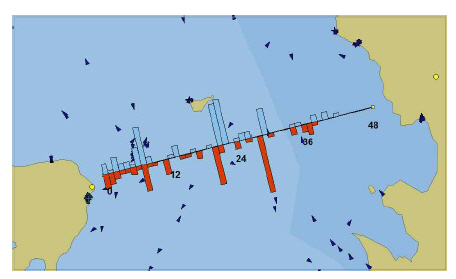
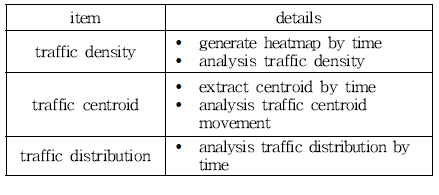
Ē׳ĒŖĖļ¦Ą(heatmap)ņØĆ Ļ│ĄĻ░ä ļŹ░ņØ┤Ēä░ņØś ļČäĒżļź╝ Ļ░Ćņŗ£ĒÖöĒĢśĻĖ░ ņ£äĒĢ£ ļ░®ļ▓Ģņ£╝ļĪ£ ļīĆņāü ņØ┤ļ»Ėņ¦Ć ņ£äņŚÉ ņŚ┤ļČäĒż ĒśĢĒā£ļĪ£ ļŹ░ņØ┤Ēä░ļź╝ Ēæ£ņŗ£ĒĢśņŚ¼ Ļ░ÆņØś ļČäĒżļź╝ ņ¦üĻ┤ĆņĀüņ£╝ļĪ£ ļ│┤ņŚ¼ņŻ╝ļŖö Ļ▓āņØ┤ ĒŖ╣ņ¦ĢņØ┤ļ®░, ļīĆņāü ņśüņŚŁ ņØś ņØ┤ļ»Ėņ¦ĆņÖĆ ņżæņ▓®ĒĢśņŚ¼ ņČ£ļĀźĒĢśļŖö Ļ▓āņØ┤ ņØ╝ļ░śņĀüņØ┤ļŗż. Ļ│ĄĻ░ä ļŹ░ņØ┤ Ēä░ņØś Ē׳ĒŖĖļ¦ĄņØä ņāØņä▒ĒĢśĻĖ░ ņ£äĒĢ┤ņä£ļŖö ļ©╝ņĀĆ ļīĆņāü ņśüņŚŁņØä ņØ╝ņĀĢ Ēü¼ ĻĖ░ņØś Ļ▓®ņ×ÉļĪ£ ĻĄ¼ļČäĒĢśĻ│Ā, ļīĆņāü ļŹ░ņØ┤Ēä░ ņżæ Ļ░ü Ļ▓®ņ×ÉņŚÉ ĒżĒĢ©ļÉśļŖö ļŹ░ņØ┤Ēä░ Ļ░ÆņØä ļłäņĀüĒĢ£ļŗż. ļłäņĀüļÉ£ ļŹ░ņØ┤Ēä░ņØś Ēü¼ĻĖ░ņŚÉ ļö░ļØ╝ Ļ░ÆņØ┤ Ēü░ ņśüņŚŁņØĆ ļČēņØĆņāē, ņāüļīĆņĀüņ£╝ļĪ£ Ļ░ÆņØ┤ ņ×æņØĆ ņśüņŚŁņØĆ ĒæĖļźĖņāēņ£╝ļĪ£ ļČä ļźśĒĢśĻ│Ā, ņ¦ĆļÅä ļŹ░ņØ┤Ēä░ņÖĆ ĒĢ©Ļ╗ś ņżæņ▓®ĒĢśņŚ¼ ļČäņäØ ņ×æņŚģņØä ņłśĒ¢ēĒĢ£ļŗż. Fig. 2ļŖö ņä£ņÜĖ ņ¦ĆņŚŁņŚÉņä£ņØś ĒŖ╣ņĀĢ ĻĖ░Ļ░ä ļÅÖņĢł ņ£ĀļÅÖņØĖĻĄ¼ ļČäĒżļź╝ Ē׳ĒŖĖļ¦ĄĻ│╝ ļō▒ņ╣śņäĀņØś ĒśĢĒā£ļĪ£ Ēæ£ņŗ£ĒĢ£ ņśłņØ┤ļŗż. ņØ┤ņ▓śļ¤╝ Ē׳ĒŖĖļ¦ĄņØĆ ņ£äņ╣śņĀü Ļ│ĄĻ░ä ĒŖ╣ņä▒ņØä Ļ░Ćņ¦ĆļŖö ĻĄÉĒåĄ ļŹ░ņØ┤Ēä░ļź╝ Ļ░Ćņŗ£ĒÖöĒĢśļŖöļŹ░ ļ¦żņÜ░ ņĀüĒĢ®ĒĢ£ ļ░®ļ▓ĢņØ┤ļ®░, ĻĄÉĒåĄļ¤ē ļ░Å ĻĄÉĒåĄļ░ĆļÅä ļČäņäØ ļō▒ņŚÉ ĒÖ£ņÜ®ļÉśĻ│Ā ņ׳ ļŗż(Vatin et al., 2013).

ĒĢ£ĒÄĖ, ņżæņŗ¼ņĀÉ ļČäņäØ ĻĖ░ļ▓ĢņØĆ Ļ│ĄĻ░ä ļŹ░ņØ┤Ēä░ņØś ņĀäņ▓┤ņĀüņØĖ Ļ▓ĮĒ¢źņØä ĒīīņĢģĒĢśļŖöļŹ░ ĒÜ©ņ£©ņĀüņØĖ ļČäņäØ ļ░®ļ▓ĢņØ┤ļ®░, ņŻ╝ļĪ£ ļīĆņāü ņ¦ĆņŚŁņØś ņØĖĻĄ¼ ļČäĒżļź╝ ļČäņäØĒĢśĻĖ░ ņ£äĒĢ┤ ņé¼ņÜ®ļÉ£ļŗż. ņżæņŗ¼ņĀÉņØĆ ĒżņØĖĒä░ ļŹ░ņØ┤Ēä░ ņ¦æ ĒĢ®ņØś ļ¼┤Ļ▓ī ņżæņŗ¼ņĀÉņØ┤ļ®░, ņŗØ (1)Ļ│╝ Ļ░ÖņØ┤ Ļ░ü ĒżņØĖĒŖĖ ļŹ░ņØ┤Ēä░ņØś Ļ░Ć ņżæ ĒÅēĻĘĀĻ░Æņ£╝ļĪ£ ņĀĢņØśĒĢ£ļŗż.
ņŚ¼ĻĖ░ņä£, wi ļŖö weight of each data
ņØ┤ļ¤¼ĒĢ£ ņØĖĻĄ¼ ņżæņŗ¼ņĀÉ ļ¬©ļŹĖņØĆ ņØĖĻĄ¼ņØś Ļ│ĄĻ░äņĀü ļČäĒż ņāüĒā£ļĪ£ļČĆ Ēä░ ņØĖĻĄ¼ ņ¦æņżæ Ļ▓ĮĒ¢ź ļ░Å ņØ┤ļÅÖ ĻČżļÅä, ļ░®Ē¢ź ļō▒ ņŗ£Ļ░äņŚÉ ļö░ļźĖ ļ│ĆļÅÖ ņČöņØ┤ļź╝ Ļ▒░ņŗ£ņĀüņ£╝ļĪ£ ĒīīņĢģĒĢśļŖöļŹ░ ĒÖ£ņÜ®ļÉ£ļŗż(Park et al., 2008).
Fig. 3ņØĆ ņłśļÅäĻČī ņ¦ĆņŚŁņØś ņØĖĻĄ¼ ņżæņŗ¼ņĀÉ ļ│ĆĒÖöļź╝ ļéśĒāĆļé┤ļ®░, ņØ┤ļź╝ ĒåĄĒĢ┤ ĻĄÉĒåĄ, ņŻ╝Ļ▒░, Ļ│ĀņÜ® ļō▒ņØś ņé¼ĒÜī ĒśäņāüĻ│╝ ņØĖĻĄ¼ ņØ┤ļÅÖĻ░äņØś Ļ┤ĆĻ│ä ļź╝ ļČäņäØĒĢśĻ│Ā Ē¢źĒøä ņØ┤ļÅÖ ņČöņäĖļź╝ ņśłņĖĪĒĢśĻĖ░ļÅä ĒĢ£ļŗż.
Ļ│ĄĻ░äņĀĢļ│┤ ļČäņäØ ĻĖ░ļ▓Ģ ņĀüņÜ®
4.1 ņŗżĒŚś Ļ░£ņÜö
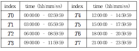
ļ│Ė ņĀłņŚÉņä£ļŖö Ē׳ĒŖĖļ¦ĄĻ│╝ ņżæņŗ¼ņĀÉ ĻĖ░ļ▓ĢņØä ņØ┤ņÜ®ĒĢ£ ĒåĄĒĢŁĒī©Ēä┤ ļČä ņäØ ņé¼ļĪĆļź╝ ĻĖ░ņłĀĒĢ£ļŗż. ņŗżĒŚś ļīĆņāüĒĢŁļ¦īņØĆ ļ¬®ĒżĒĢŁņØ┤ļ®░, ņŗ£Ļ░äļīĆņŚÉ ļö░ļźĖ ĻĄÉĒåĄ ļ░ĆļÅä ļ░Å ņżæņŗ¼ņĀÉ ņØ┤ļÅÖ ļČäņäØņØä ņłśĒ¢ēĒĢśĻ│Ā, ĻĘĖ Ļ▓░Ļ│╝ļź╝ Ļ│Āņ░░ĒĢ£ļŗż. ņŗ£Ļ░äļīĆļŖö Table 1Ļ│╝ Ļ░ÖņØ┤ 3ņŗ£Ļ░ä ļŗ©ņ£äņØś ņ┤Ø 8Ļ░£ņØś ĻĄ¼Ļ░äņ£╝ļĪ£ ĻĄ¼ļČäĒĢśņśĆļŗż.
ņŗżĒŚś ĒĢŁļ¬®ņØĆ ĻĄÉĒåĄ ļ░ĆļÅä ļČäņäØ, ĻĄÉĒåĄ ņżæņŗ¼ņĀÉ ļČäņäØ, ĻĄÉĒåĄ ļČäĒż ļČäņäØņ£╝ļĪ£ ĻĄ¼ņä▒ļÉśļ®░, Ļ░ü ņŗ£Ļ░äļīĆļ│äļĪ£ ņŗżĒŚśņØä ņłśĒ¢ēĒĢśņśĆļŗż. Table 2ļŖö ņŗżĒŚś ĒĢŁļ¬®ņØś ņäĖļČĆņé¼ĒĢŁņØ┤ļŗż.
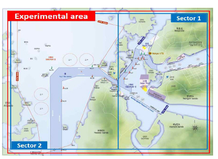
4.2 ņŗżĒŚś ļīĆņāüĒĢŁļ¦īņØś ĒŖ╣ņ¦Ģ
ļ¬®ĒżĒĢŁņØĆ ļé©ĒĢŁ, ļČüĒĢŁ, ņŗĀĒĢŁņ£╝ļĪ£ ĻĄ¼ņä▒ļÉśļ®░, ņŚ░Ļ░ä 132ļ¦ī ĒåżņØś ĒĢśņŚŁļŖźļĀźņØä Ļ░Ćņ¦ä ļ¼┤ņŚŁĒĢŁņØ┤ļŗż. Fig. 4ņÖĆ Ļ░ÖņØ┤ Ļ┤ĆņĀ£ĻĄ¼ņŚŁ ļé┤ņŚÉļŖö ņ┤Ø 11Ļ░£ņØś ļČĆļæÉĻ░Ć ņäżņ╣śļÉśņ¢┤ ņ׳ņ£╝ļ®░, ĒĢŁĻ│ä ļé┤ 10Ļ░£ņØś ņĀĢļ░Ģņ¦ĆĻ░Ć ņÜ┤ņśüļÉśĻ│Ā ņ׳ļŗż. ņŻ╝ņ£äņŚÉļŖö ļŗżņłśņØś ņé░ņŚģ ļŗ©ņ¦ĆĻ░Ć ņŚ░Ļ▓░ļÉśņ¢┤ ņ׳Ļ│Ā, ņŚ¼ļ¤¼ ļÅäņä£ ņ¦ĆņŚŁņØä ņŚ░Ļ▓░ĒĢśļŖö ņŚ░ņĢł ņŚ¼Ļ░Ø Ēä░ļ»ĖļäÉņØ┤ ņÜ┤ņśüļÉśĻ│Ā ņ׳ ņ¢┤ņä£ ĒÖöļ¼╝ņäĀ, ņŚ¼Ļ░ØņäĀ, ņ¢┤ņäĀ, ļĀłņĀĆņäĀļ░Ģ ļō▒ ļŗżņ¢æĒĢ£ ņäĀņóģņØ┤ Ēś╝ņ×¼ ĒĢśļŖö ĒŖ╣ņ¦ĢņØä Ļ░Ćņ¦äļŗż(Mokpo Regional Office of Ocean and Fisheries, 2018). ļśÉĒĢ£, ņŻ╝ņ£ä ļÅäņä£ ĻĄ¼Ļ░äņØä ĒåĄĒĢŁĒĢśļŖö ĒĢŁļĪ£Ļ░Ć ļ¦Ä ņĢä ĒśæņłśļĪ£ ĻĄ¼Ļ░äņØ┤ ļ¦ÄĻ│Ā, ļČłļ▓Ģ ņ¢┤ļ¦Ø ļ░Å ņ¢æņŗØņןņØ┤ ņé░ņ×¼ĒĢ┤ ņ׳ĻĖ░ ļĢīļ¼ĖņŚÉ ĒĢŁĒĢ┤ņŚÉ Ļ░üļ│äĒĢ£ ņŻ╝ņØśĻ░Ć ĒĢäņÜöĒĢśļŗż. ņØ┤ņŚÉ ĒĢŁļé┤ņŚÉ VTS ņä╝ Ēä░Ļ░Ć ņäżņ╣śļÉśņ¢┤ ņÜ┤ņśü ņżæņØ┤ļ®░, ņĄ£ĻĘ╝ņŚÉļŖö Ļ░Ćņé¼ļÅäņŚÉņä£ ņé¼ĒĢśļÅä ĻĄ¼ Ļ░äņØś ņ×ģņČ£ĒĢŁ ĒĢŁļĪ£ļź╝ ĒżĒĢ©ĒĢśļÅäļĪØ Ļ┤ĆņĀ£ļ▓öņ£äļź╝ ĒÖĢļīĆĒĢśņŚ¼ Ēśäņ×¼ ņ┤Ø 3Ļ░£ņØś Ļ┤ĆņĀ£ņä╣Ēä░Ļ░Ć ņÜ┤ņśüļÉśĻ│Ā ņ׳ļŗż(Jong et al., 2005).
4.3 ļČäņäØ ļŹ░ņØ┤Ēä░ ĻĄ¼ņä▒
ņŗżĒŚśņŚÉļŖö ļ¬®Ēż VTS ņä╝Ēä░ņŚÉņä£ 6Ļ░£ņøö ļÅÖņĢł(2017ļģä 7ņøöļČĆĒä░ 12ņøöĻ╣īņ¦Ć) ņłśņ¦æļÉ£ ĒĢŁņĀü ļŹ░ņØ┤Ēä░ļź╝ ņé¼ņÜ®ĒĢśņśĆņ£╝ļ®░, ņŗżĒŚś ļ▓öņ£äļŖö ļ¬®Ēż VTS ņä╝Ēä░ņØś 1 Ļ┤ĆņĀ£ņä╣Ēä░ņÖĆ 2 Ļ┤ĆņĀ£ņä╣Ēä░ļź╝ ĒżĒĢ©ĒĢśļŖö ņśüņŚŁ ņ£╝ļĪ£ ņäżņĀĢĒĢśņśĆļŗż. ņłśņ¦æļÉ£ ĒĢŁņĀü ļŹ░ņØ┤Ēä░ļŖö AIS ļŹ░ņØ┤Ēä░ņÖĆ RADAR ļ¼╝Ēæ£ ļŹ░ņØ┤Ēä░ļĪ£ ĻĄ¼ņä▒ļÉśļ®░, AIS ņäĀļ░ĢņĀĢļ│┤ņÖĆ RADAR ļ¼╝Ēæ£Ļ░äņØś ņŚ░Ļ▓░ ņĀĢļ│┤ļź╝ ĒżĒĢ©ĒĢśĻ│Ā ņ׳ļŗż. ļ│Ė ņŗżĒŚśņŚÉņä£ļŖö ņØ┤ļź╝ ņØ┤ ņÜ®ĒĢśņŚ¼ ĒĢŁņĀü ļŹ░ņØ┤Ēä░ņØś ņżæļ│Ą ņĀ£Ļ▒░ ņ×æņŚģņØä ņłśĒ¢ēĒĢ£ Ēøä, ņĢ×ņä£ ņĀĢņØś ĒĢ£ ņŗ£Ļ░äļīĆ ļ│äļĪ£ ļŹ░ņØ┤Ēä░ļź╝ ĻĄ¼ļČäĒĢśņśĆļŗż. ĻĘĖ Ēøä, ņŗ£Ļ░äļīĆ ļ│äļĪ£ ĻĄ¼ ļČäļÉ£ ļŹ░ņØ┤Ēä░ ņżæ 2 ļ░▒ļ¦ī Ļ▒┤ņØś ļŹ░ņØ┤Ēä░ļź╝ ļ¼┤ņ×æņ£äļĪ£ ņäĀļ│äĒĢśņśĆĻ│Ā, 8 Ļ░£ņØś ņŗ£Ļ░äļīĆņŚÉ ļīĆĒĢ┤ ņ┤Ø 1ņ▓£ 6ļ░▒ļ¦ī Ļ▒┤ņØś ĒĢŁņĀü ļŹ░ņØ┤Ēä░Ļ░Ć ĒżĒĢ©ļÉ£ ļŹ░ņØ┤Ēä░ ņäĖĒŖĖļź╝ ņāØņä▒ĒĢśņśĆļŗż.
Ļ░üĻ░üņØś ĒĢŁņĀü ļŹ░ņØ┤Ēä░ļŖö ņäĀļ░ĢņØś ņ£äļÅä, Ļ▓ĮļÅä, ņ╣©ļĪ£, ņåŹļÅäļĪ£ ĻĄ¼ ņä▒ļÉ£ļŗż. ņäĀļ░ĢņØś ņ£äņ╣ś ņĀĢļ│┤ļŖö ņ£äļÅäņÖĆ Ļ▓ĮļÅäļĪ£ Ēæ£ĒśäļÉśļ®░, ļŗ©ņ£äļŖö ļÅä(degree)ņØ┤ļŗż. ļśÉĒĢ£, ņäĀļ░ĢņØś ņ╣©ļĪ£ ņĀĢļ│┤ļŖö ļČüņ¬ĮņØä ĻĖ░ņżĆņ£╝ļĪ£ 0┬░ņŚÉņä£ 360┬░ ņé¼ņØ┤ņØś ļ░®ņ£ä Ļ░Æņ£╝ļĪ£ Ēæ£ĒśäļÉśļ®░, ņäĀļ░ĢņØś ņåŹļÅä ņĀĢļ│┤ ļŖö ļīĆņ¦ĆņåŹļÅä(SOG, Speed Of Ground)ļź╝ ņé¼ņÜ®ĒĢśĻ│Ā, ļŗ©ņ£äļŖö ļģĖ ĒŖĖ(knot)ņØ┤ļŗż. ļśÉĒĢ£, Ļ░ü ļŹ░ņØ┤Ēä░ ĒĢŁļ¬®ņØĆ ņĮżļ¦ł(,)ļĪ£ ĻĄ¼ļČäĒĢśņŚ¼ ĒģŹ ņŖżĒŖĖ ĒīīņØ╝ ĒśĢĒā£ļĪ£ ņĀĆņןĒĢśņśĆļŗż.
4.4 ĻĄÉĒåĄ ļ░ĆļÅä ļČäņäØ
ņŗ£Ļ░äļīĆ ļ│äļĪ£ ņāØņä▒ļÉ£ ĒĢŁņĀü ļŹ░ņØ┤Ēä░ ņäĖĒŖĖļź╝ ļ░öĒāĢņ£╝ļĪ£ Ē׳ĒŖĖļ¦Ą ņØä ņāØņä▒ĒĢśņśĆņ£╝ļ®░, ĻĘĖ Ļ▓░Ļ│╝ļŖö Fig. 5ņÖĆ Ļ░Öļŗż. Ē׳ĒŖĖļ¦ĄņŚÉļŖö ĒĢŁņĀü ļŹ░ņØ┤Ēä░ņØś ļ░ĆļÅäĻ░Ć ņāüļīĆņĀüņ£╝ļĪ£ ļåÆņØĆ ļČĆļČäņØ┤ ļČēņØĆņāēņ£╝ļĪ£ Ēæ£ņŗ£ļÉś ļ®░, ņØ┤ļź╝ ĒåĄĒĢ┤ ĒĢŁņĀü ļČäĒżņØś ļ░ĆļÅäļź╝ ĒĢ£ļłłņŚÉ ĒīīņĢģĒĢĀ ņłś ņ׳ļŗż. Fig. 5ņØś (a)ņÖĆ Ļ░ÖņØ┤ Ē׳ĒŖĖļ¦ĄņØä ĒåĄĒĢ┤ ļ░Ćņ¦æļÅäņØś ļ│ĆļÅÖņØ┤ ņ׳ļŖö ņŗ£ Ļ░äļīĆļź╝ ņēĮĻ▓ī ņŗØļ│äĒĢĀ ņłś ņ׳ņ£╝ļ®░, ļ│Ė ņĀłņŚÉņä£ļŖö ņØ┤ ņżæ ļÜ£ļĀĘĒĢ£ ļ│Ć ĒÖöĻ░Ć ņ׳ļŖö T2 , T3 ņŗ£Ļ░äļīĆņØś Ē׳ĒŖĖļ¦Ą ņĀĢļ│┤ļź╝ ņØ┤ņÜ®ĒĢśņŚ¼ ļŗżņØīĻ│╝ Ļ░ÖņØ┤ ĻĄÉĒåĄ ļ░ĆļÅä ļČäņäØņØä ņłśĒ¢ēĒĢśņśĆļŗż. T2 ņŗ£Ļ░äļīĆļŖö 06ņŗ£ļČĆĒä░ 09ņŗ£Ļ╣īņ¦ĆņØ┤ļ®░, Fig. 5ņØś (b)ņŚÉņä£ņÖĆ Ļ░ÖņØ┤ ļ¬®ĒżĒĢŁņØś ļČüņä£ņ¬ĮņŚÉ ņ£ä ņ╣śĒĢ£ ņåĪĻ│ĄĒĢŁĻ│╝ ņŗĀņäØĒĢŁ ļ░®Ē¢źņ£╝ļĪ£ņØś ĒĢŁļĪ£ņŚÉ ļ░Ćņ¦æļÅäĻ░Ć ņ”ØĻ░ĆĒĢ£ Ļ▓ā ņ£╝ļĪ£ ļéśĒāĆļé¼ļŗż(ŌæĀļ▓ł ņśüņŚŁ). ĒĢ┤ļŗ╣ ĒĢŁņĀüņØś ņäĖļČĆ ņĀĢļ│┤ļź╝ ļČäņäØĒĢ£ Ļ▓░Ļ│╝, ņ¢┤ņäĀĻ│╝ ņŚ¼Ļ░ØņäĀ, ĒÖöļ¼╝ņäĀ ļō▒ ļŗżņ¢æĒĢ£ ņäĀņóģņØ┤ ļČäĒżĒĢśļ®░, ņ×ģ ĒĢŁĻ│╝ ņČ£ĒĢŁņØś ļ╣äņ£©ļÅä ļ╣äņŖĘĒĢśņśĆļŗż. ņØ┤ļŖö ņØ╝Ļ│╝ņŗ£Ļ░äņØś ņŗ£ņ×æĻ│╝ ĒĢ© Ļ╗ś ņ¢┤ņäĀ ļ░Å ņŚ¼Ļ░ØņäĀņØś ĒåĄĒĢŁļ¤ēņØ┤ ņ”ØĻ░ĆĒĢ£ Ļ▓āņ£╝ļĪ£ ĒīÉļŗ©ļÉ£ļŗż. ĒĢ£ĒÄĖ, ļČłļ¼┤ĻĖ░ļÅä ļé©ļŗ©ņØś ļ¼śļ░Ģņ¦Ć ņśüņŚŁņØś ĻĄÉĒåĄ ļ░ĆļÅä ļ│ĆĒÖöļÅä ņŗØļ│äļÉśņŚłļŗż (Ōæóļ▓ł ņśüņŚŁ). T3 ņŗ£Ļ░äļīĆļŖö 09ņŗ£ļČĆĒä░ 12ņŗ£Ļ╣īņ¦ĆņØ┤ļ®░, Fig. 5ņØś (c)ņÖĆ Ļ░ÖņØĆ ĻĄÉĒåĄ ļ░ĆļÅäļź╝ ļ│┤ņśĆļŗż. T2ņŗ£Ļ░äļīĆņŚÉ ņØ┤ņ¢┤ņä£ ļ¬®ĒżĒĢŁ ņØś ļČüņä£ņ¬ĮņŚÉ ņ£äņ╣śĒĢ£ ņŻ╝ņ£ä ļÅäņä£ļōżņØä ņŚ░Ļ▓░ĒĢśļŖö ĒĢŁļĪ£ņØś ĒåĄĒĢŁļ¤ēņØ┤ ņ”ØĻ░ĆĒĢśņśĆņ£╝ļ®░, ĒŖ╣Ē׳, ņåĪĻ│Ą-ĒīöĻĖłļÅä Ļ░ä ĻĄÉĒåĄ ļ░ĆļÅä ļ│ĆĒÖöĻ░Ć ļÜ£ļĀĘĒĢś ņśĆļŗż(ŌæŻļ▓ł ņśüņŚŁ). ĒĢ£ĒÄĖ, ļČłļ¼┤ĻĖ░ļÅä ĻĘ╝ņ▓ś ĒĢ┤ņāüņØś ĒĢŁļĪ£ ĻĄÉņ░© ņśüņŚŁ ņØś ļ░Ćņ¦æļÅäĻ░Ć ņ”ØĻ░ĆĒĢśņśĆņ£╝ļ®░, ĒÖöņøÉļ░śļÅä ĒĢ┤ņĢłņØä ļö░ļØ╝ ņØ┤ļÅÖĒĢśļŖö ņäĀļ░ĢņØś ņØ┤ļÅÖņØ┤ ļ¦ÄņĢäņ¦ÉņØä ņĢī ņłś ņ׳ņŚłļŗż(Ōæźļ▓ł ņśüņŚŁ). ļśÉĒĢ£, Fig. 5ņØś (b), (c)ņŚÉņä£ No. 10 ļ¼śļ░Ģņ¦ĆņØś ļ░ĆļÅäĻ░Ć ņ¦ĆņåŹņĀüņ£╝ļĪ£ ņ”ØĻ░ĆĒĢś ļŖö ņČöņäĖļź╝ ļ│┤ņśĆļŗż(ŌæĪļ▓ł, Ōæżļ▓ł ņśüņŚŁ). ņØ┤ņ▓śļ¤╝ ĻĄÉĒåĄ ļ░Ćņ¦æļÅäĻ░Ć ļåÆ ņØĆ ņśüņŚŁņØĆ ņČ®ļÅīņé¼Ļ│ĀĻ░Ć ļ░£ņāØĒĢĀ Ļ░ĆļŖźņä▒ņØ┤ Ēü¼ļŗżĻ│Ā ĒīÉļŗ©ĒĢĀ ņłś ņ׳ ņ£╝ļ®░, ĒŖ╣Ē׳ ĻĖēĻ▓®ĒĢśĻ▓ī ļ░Ćņ¦æļÅäĻ░Ć ņ”ØĻ░ĆĒĢśļŖö Ļ▓ĮņÜ░ļŖö ĒĢ┤ļŗ╣ ņŗ£Ļ░äļīĆ ņÖĆ ĒĢ┤ļŗ╣ ņśüņŚŁņŚÉ ĒŖ╣ļ│äĒĢ£ Ļ┤ĆņĀ£ ņŻ╝ņØśĻ░Ć ĒĢäņÜöĒĢĀ Ļ▓āņ£╝ļĪ£ ņāØĻ░üļÉ£ļŗż. ļśÉĒĢ£, ļ¼śļ░Ģņ¦Ć ņśüņŚŁņØś ņŗ£Ļ░äļīĆļ│ä ĻĄÉĒåĄ ļ░ĆļÅä ņĀĢļ│┤ļŖö ļ¼śļ░Ģņ¦Ć ņÜ┤ņśü ņŚÉ ņ░ĖĻ│ĀĻ░Ć ļÉĀ ņłś ņ׳ņ£╝ļ®░, ņØ┤ļź╝ ĒåĄĒĢ┤ ĒĢŁļ¦īņØś ņÜ┤ņśü ĒÜ©ņ£©ņØä Ē¢źņāü ņŗ£Ēé¼ ņłś ņ׳ņØä Ļ▓āņ£╝ļĪ£ ņé¼ļŻīļÉ£ļŗż.

4.5 ĻĄÉĒåĄ ļČäĒż ņżæņŗ¼ņĀÉ ļČäņäØ
ļ│Ė ļģ╝ļ¼ĖņŚÉņä£ ĻĄÉĒåĄ ļČäĒż ņżæņŗ¼ņĀÉņØĆ ĒĢŁņĀü ļŹ░ņØ┤Ēä░ņØś ļ¼┤Ļ▓ī ņżæņŗ¼ ņĀÉņØä ņØśļ»ĖĒĢśļ®░, ņåŹļÅäĻ░Æ(SOG)ņØä ņżæņŗ¼ņĀÉ Ļ│äņé░ņØś Ļ░Ćņżæņ╣śļĪ£ ņé¼ņÜ® ĒĢśņśĆļŗż. ĻĄÉĒåĄ ļČäĒż ņżæņŗ¼ņĀÉņØĆ ņŗ£Ļ░äņŚÉ ļö░ļØ╝ Fig. 6ņØś (a)ņÖĆ Ļ░ÖņØ┤ ņ×äĒĢśļÅä ļČĆĻĘ╝ņŚÉņä£ ņØ┤ļÅÖĒĢśņśĆņ£╝ļ®░, ņØ┤ļź╝ ĒåĄĒĢ┤ ņŗ£Ļ░äņŚÉ ļö░ļźĖ ĻĄÉĒåĄ Ēī©Ēä┤ņØś ņČöņØ┤ļź╝ ļČäņäØĒĢĀ ņłś ņ׳ļŗż. Ļ░ü ņŗ£Ļ░äļīĆņØś ņżæņŗ¼ņĀÉņØĆ Table 3ņØś A ņÖĆ Ļ░Öņ£╝ļ®░, B ĒĢŁļ¬®ņØĆ ņŗ£Ļ░äņŚÉ ļö░ļźĖ ņżæņŗ¼ņĀÉņØś ņØ┤ļÅÖ Ļ▒░ļ”¼ ļź╝ ļéśĒāĆļéĖļŗż. ņŗżĒŚś Ļ▓░Ļ│╝, T1-T2, T5-T6 ĻĄ¼Ļ░äņŚÉņä£ ņżæņŗ¼ņĀÉ ņØ┤ ļÅÖņØ┤ Ēü░ Ļ▓āņ£╝ļĪ£ ļéśĒāĆļé¼ņ£╝ļ®░, Ļ░üĻ░ü ļČüņä£ņ¬Į, ļÅÖņ¬Įņ£╝ļĪ£ ĻĄÉĒåĄ ļČäĒż ņżæņŗ¼ņĀÉņØ┤ ņØ┤ļÅÖĒĢ£ Ļ▓āņØä ņĢī ņłś ņ׳ņŚłļŗż. ņØ┤ļĀćĻ▓ī ņżæņŗ¼ņĀÉ ņØ┤ļÅÖņØ┤ Ēü░ ĻĄ¼Ļ░äņØĆ ņ£ĀņØśļ»ĖĒĢ£ ĒåĄĒĢŁĒī©Ēä┤ņØś ļ│ĆĒÖöĻ░Ć ņ׳ņØīņØä ņŗ£ņé¼ ĒĢśļ®░, ņØ┤ņŚÉ ļö░ļØ╝ ĒĢ┤ļŗ╣ ĻĄ¼Ļ░äņŚÉņä£ ĒĢ┤ņāüĻĄÉĒåĄĻ┤ĆņĀ£ļź╝ ņ£äĒĢ£ Ļ░üļ│äĒĢ£ ņŻ╝ņØśĻ░Ć ĒĢäņÜöĒĢśļŗżĻ│Ā ĒīÉļŗ©ĒĢĀ ņłś ņ׳ļŗż.
Fig.┬Ā6
Result of centroid analysis; (a) centroid of traffic density, (b) distribution of traffic density
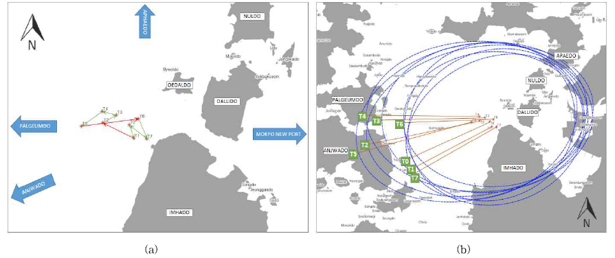
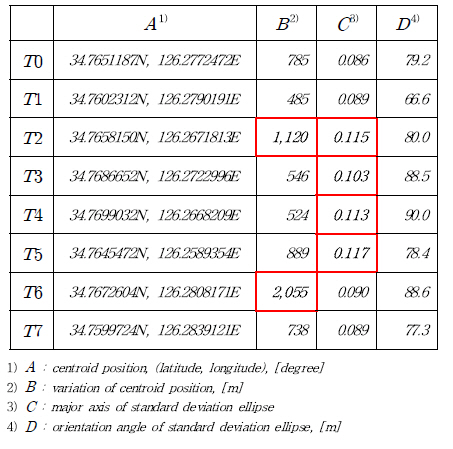
ļśÉĒĢ£, Fig. 6ņØś (b)ņÖĆ Ļ░ÖņØ┤ ĒĢŁņĀü ļŹ░ņØ┤Ēä░ņØś Ēæ£ņżĆĒÄĖņ░©ĒāĆņøÉ (SDE, Standard Deviation Ellipse)ņØä ĒåĄĒĢ┤ ļŹ░ņØ┤Ēä░ņØś ļČäĒż ĒŖ╣ ņä▒ņØä ĒīīņĢģĒĢĀ ņłś ņ׳ļŗż. Ēæ£ņżĆĒÄĖņ░©ĒāĆņøÉņØĆ 2ņ░©ņøÉ Ļ│ĄĻ░ä ļŹ░ņØ┤Ēä░ņØś ļČäĒżļź╝ Ļ░ü ņ░©ņøÉņØś Ēæ£ņżĆĒÄĖņ░©ļź╝ ņØ┤ņÜ®ĒĢśņŚ¼ ĒāĆņøÉ ĒśĢĒā£ļĪ£ Ēæ£ĒśäĒĢśļŖö ļ░®ļ▓Ģņ£╝ļĪ£ ļČäĒżņØś ļ░®Ē¢źņä▒Ļ│╝ ļČäĒż ļ▓öņ£äļź╝ ņČöņĀĢĒĢśļŖöļŹ░ ĒÖ£ņÜ®ņØ┤ Ļ░Ć ļŖźĒĢśļŗż(Shi et al., 2018). ļ│Ė ņŗżĒŚśņŚÉņä£ņØś Ēæ£ņżĆĒÄĖņ░©ĒāĆņøÉņØś ņןņČĢ Ēæ£ņżĆĒÄĖņ░©ņÖĆ ĻĖ░ņÜĖĻĖ░ Ļ░ÆņØĆ Table 3ņØś C , D ĒĢŁļ¬®Ļ│╝ Ļ░Öņ£╝ļ®░, T2, T3, T4, T5 ņŗ£Ļ░äļīĆņØś Ēæ£ņżĆĒÄĖņ░©Ļ░Ć ņāüļīĆņĀüņ£╝ļĪ£ Ēü¼Ļ▓ī ļéśĒāĆļé¼Ļ│Ā, ĒĢ┤ļŗ╣ ņŗ£Ļ░äļīĆņØś ĻĄÉĒåĄ ļČäĒżĻ░Ć ļÅÖ-ņä£ ļ░®Ē¢źņ£╝ļĪ£ ļäōņ¢┤ņ¦ÉņØä ņĢī ņłś ņ׳ņŚłļŗż. ņØ┤ļ¤¼ĒĢ£ Ļ▓░Ļ│╝ļŖö Ļ┤ĆņĀ£ĻĄ¼ņŚŁ ļ░Å Ļ┤ĆņĀ£ņä╣Ēä░ļź╝ ņäżņĀĢĒĢśļŖöļŹ░ ĻĖ░ņ┤łņ×ÉļŻīļĪ£ ĒÖ£ņÜ®ļÉĀ ņłś ņ׳ņ£╝ļ®░, Ļ┤ĆņĀ£ņé¼ņØś ĒŖ╣ļ│äĒĢ£ ņŻ╝ņØśĻ░Ć ĒĢäņÜö ĒĢ£ ņŗ£Ļ░äļīĆņÖĆ ĻĄ¼ņŚŁņØä ņäżņĀĢĒĢśļŖöļŹ░ ņ░ĖĻ│ĀĻ░Ć ļÉĀ ņłś ņ׳ļŗż.
Ļ▓░ ļĪĀ
ļ│Ė ļģ╝ļ¼ĖņŚÉņä£ļŖö Ļ│ĄĻ░äņĀĢļ│┤ ļČäņäØ ĻĖ░ļ▓ĢņØĖ Ē׳ĒŖĖļ¦ĄĻ│╝ ņżæņŗ¼ņĀÉ ĻĖ░ ļ▓ĢņØä ņåīĻ░£ĒĢśĻ│Ā, ļ¬®ĒżĒĢŁņØś ņĀüņÜ® ņé¼ļĪĆļź╝ ĒåĄĒĢ┤ ĒĢ┤ņāüĻĄÉĒåĄ ļČäņäØ ļ░® ļ▓Ģņ£╝ļĪ£ņä£ņØś ņĀüņÜ® Ļ░ĆļŖźņä▒ņØä Ļ▓ĆĒåĀĒĢśņśĆļŗż. ņżæņŗ¼ņĀÉ ĻĖ░ļ▓ĢņØĆ ļŹ░ņØ┤Ēä░ ņØś ņżæņŗ¼ņĀÉ ņĀĢļ│┤ļź╝ ĒåĄĒĢ┤ Ļ│ĄĻ░äņĀü ļČäĒż ņāüĒā£ļź╝ ļČäņäØĒĢśĻ│Ā, ņŗ£Ļ░äņŚÉ ļö░ļźĖ ļ│ĆļÅÖ ņČöņØ┤ļź╝ Ļ▒░ņŗ£ņĀüņ£╝ļĪ£ ĒīīņĢģĒĢĀ ņłś ņ׳ļŖö ĒŖ╣ņ¦ĢņØ┤ ņ׳ņ¢┤ņä£ ĒĢŁņĀü ļŹ░ņØ┤Ēä░ņØś ņŗ£Ļ│äņŚ┤ ļČäņäØņŚÉ ļ¦żņÜ░ ņĀüĒĢ®ĒĢ£ ļČäņäØ ļ░®ļ▓ĢņØ┤ļŗż.
ļśÉĒĢ£, ņŗżņĀ£ ļ¬®ĒżĒĢŁņŚÉņä£ ņłśņ¦æļÉ£ ĒĢŁņĀü ļŹ░ņØ┤Ēä░ļź╝ ņĀüņÜ®ĒĢ£ ņŗżĒŚś ņŚÉņä£ļŖö Ē׳ĒŖĖļ¦ĄĻ│╝ ņżæņŗ¼ņĀÉ ņØ┤ļÅÖ ļČäņäØņØä ĒåĄĒĢ┤ ļŗżņ¢æĒĢ£ ļČäņäØ Ļ▓░Ļ│╝ ļōżņØä ļÅäņČ£ĒĢĀ ņłś ņ׳ņŚłņ£╝ļ®░, ņØ┤ļŖö Ļ┤ĆņĀ£ĻĄ¼ņŚŁ ļ░Å ņä╣Ēä░ ņäżņĀĢņØä ņ£äĒĢ£ ņĀĢļ¤ēņĀüņØĖ ņ¦ĆĒæ£ļĪ£ ĒÖ£ņÜ®ļÉĀ ņłśļÅä ņ׳ņØä Ļ▓āņØ┤ļŗż.
ļ│Ė ļģ╝ļ¼ĖņŚÉņä£ļŖö ĒĢŁņĀü ļŹ░ņØ┤Ēä░ļź╝ 3ņŗ£Ļ░ä ļŗ©ņ£äļĪ£ ĻĄ¼ļČäĒĢśĻ│Ā, ĻĄÉĒåĄ ļ░ĆļÅäņÖĆ ņżæņŗ¼ņĀÉ ņØ┤ļÅÖņØä ļČäņäØĒĢśņśĆļŗż. ĻĘĖļ¤¼ļéś ņ×ģņČ£ĒĢŁņØ┤ ļ¦ÄņØĆ ĻĄÉ ĒåĄ Ēś╝ņ×Ī ņŗ£Ļ░äļīĆņØś Ļ▓ĮņÜ░, ņŚ¼ļ¤¼ ĒåĄĒĢŁĒī©Ēä┤ņØ┤ ļÅÖņŗ£ņŚÉ ļ░£ņāØĒĢśĻĖ░ ļĢī ļ¼ĖņŚÉ ņØ┤ļź╝ ĻĄ¼ļČäĒĢśĻĖ░ ņ¢┤ļĀżņÜ┤ ļ¼ĖņĀ£ņĀÉņØ┤ ņ׳ņŚłņ£╝ļ®░, ņØ┤ļź╝ ĒĢ┤Ļ▓░ĒĢś ĻĖ░ ņ£äĒĢ┤ ĒåĄĒĢŁļ¤ēņŚÉ ļö░ļØ╝ ņŗ£Ļ░äļīĆļź╝ ņäĖļČäĒÖöĒĢśļŖö ļ░®ļ▓ĢņØä ņĀüņÜ®ĒĢĀ ņłś ņ׳ņØä Ļ▓āņØ┤ļŗż. ĒŖ╣Ē׳, ņ¢┤ņäĀņØś Ļ▓ĮņÜ░ ņÜ┤ĒĢŁ ņŗ£ĻĖ░ņŚÉ ļö░ļØ╝ ļ¦żņÜ░ ļŗż ļźĖ ĒåĄĒĢŁĒī©Ēä┤ņØä Ļ░Ćņ¦ĆĻ│Ā ņ׳ņ£╝ļ®░, ņØ┤ņŚÉ ĒĢŁņĀü ļŹ░ņØ┤Ēä░ļź╝ ņäĀņóģļ│ä, Ļ│ä ņĀłļ│ä, ņøöļ│ä, ņŚ░Ļ░äņ£╝ļĪ£ ĻĄ¼ļČäĒĢśņŚ¼ ĻĄÉĒåĄ ļ░ĆļÅäņÖĆ ņżæņŗ¼ņĀÉ ņØ┤ļÅÖņØä ļČä ņäØĒĢśļŖö Ļ▓āļÅä Ēü░ ņØśļ»ĖĻ░Ć ņ׳ņØä Ļ▓āņ£╝ļĪ£ ņé¼ļŻīļÉ£ļŗż. ļśÉĒĢ£, ĒĢŁņĀü ļŹ░ ņØ┤Ēä░ņŚÉ ĒżĒĢ©ļÉśņ¢┤ ņ׳ļŖö ņĀĢļ░Ģ ņäĀļ░ĢņŚÉ ļīĆĒĢ£ ĒĢäĒä░ļ¦ü ļ░®ļ▓ĢņØä ĒåĄĒĢ┤ ļČäņäØ Ļ▓░Ļ│╝ņØś ņŗĀļó░ļÅäļź╝ Ē¢źņāü ņŗ£Ēé¼ ņłśļÅä ņ׳ņØä Ļ▓āņØ┤ļŗż.
ļ│Ė ņŗżĒŚśņŚÉļŖö 6Ļ░£ņøöĻ░äņØś ĒĢŁņĀü ļŹ░ņØ┤Ēä░ļ¦īņØä ņé¼ņÜ®Ē¢łĻĖ░ ļĢīļ¼ĖņŚÉ ļČäņäØ Ļ▓░Ļ│╝ ņżæ ņØ╝ļČĆļŖö ĒåĄĒĢŁĒī©Ēä┤ņ£╝ļĪ£ ņØ╝ļ░śĒÖöĒĢśĻĖ░ņŚÉ ļŗżņåī ļ¼┤ļ”¼Ļ░Ć ņ׳ņØä ņłś ņ׳ņ£╝ļ®░, ļ│┤ļŗż ņśżļ×£ ĻĖ░Ļ░äņØś ļŹ░ņØ┤Ēä░ļź╝ ņĀüņÜ®ĒĢ£ļŗżļ®┤ ņØ┤ļ¤¼ ĒĢ£ ļ¼ĖņĀ£ļź╝ ĒĢ┤Ļ▓░ĒĢĀ ņłś ņ׳ņØä Ļ▓āņ£╝ļĪ£ ĒīÉļŗ©ļÉ£ļŗż. ņØ┤ļ¤¼ĒĢ£ Ļ┤ĆņĀÉņŚÉņä£ ĒĢ┤ņāüĻĄÉĒåĄ ļŹ░ņØ┤Ēä░ņØś ĒÖĢļ│┤ļŖö ļ¦żņÜ░ ņżæņÜöĒĢ£ ņØ┤ņŖłņØ┤ļ®░, ĒŖ╣Ē׳ VTS ņä╝Ēä░ņŚÉņä£ ņłśņ¦æļÉśļŖö Ļ┤ĆņĀ£ ņĀĢļ│┤ļŖö ļ╣ģļŹ░ņØ┤Ēä░ļĪ£ņä£ Ēü░ ņØśļ»Ėļź╝ Ļ░Ćņ¦ä ļŗżĻ│Ā ĒĢĀ ņłś ņ׳ļŗż. ņØ┤ņŚÉ ļŗżņ¢æĒĢ£ ĒśĢĒā£ņØś Ļ┤ĆņĀ£ ņĀĢļ│┤ļōżņØä ņ▓┤Ļ│äņĀüņ£╝ ļĪ£ Ļ┤Ćļ”¼ĒĢĀ ņłś ņ׳ļŖö Ļ┤ĆņĀ£ ļ╣ģļŹ░ņØ┤Ēä░ ņŗ£ņŖżĒģ£ņØ┤ ĒĢäņłśņĀüņØ┤ļ®░, ņØ┤ļź╝ ļ░öĒāĢņ£╝ļĪ£ ļŗżņ¢æĒĢ£ ņŚ░ĻĄ¼Ļ░£ļ░£ņØ┤ ņ¦äĒ¢ēļÉśņ¢┤ Ē¢źĒøä ĒĢ┤ņ¢æņé¼Ļ│Ā ļ░®ņ¦ĆņŚÉ ĻĖ░ņŚ¼ĒĢĀ ņłś ņ׳ĻĖ░ļź╝ ĻĖ░ļīĆĒĢ£ļŗż.
 PDF Links
 PubReader
 Full text via DOI
 Download Citation
 Print
Print